
Storm Eowyn Wreaks Havoc Across Ireland
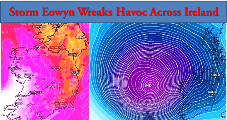
Dublin: Storm Eowyn has unleashed widespread destruction and panic across Ireland, with wind gusts of up to 200 km/h expected along the coasts of Clare, Galway, Mayo, and Donegal. The Met Office has issued an urgent warning, advising extreme caution as the storm intensifies beyond initial forecasts.
Record-Breaking Winds
In its latest update, the Met Office reported wind gusts reaching 174 km/h this morning, recorded at the synoptic weather station in Cian Mhása, Connemara, Galway. Other significant wind speeds include:
- Shannon: 137 km/h
- Knock: 130 km/h
- Roche’s Point, Cork: 111 km/h, with gusts later reaching 81 km/h
The rapidly developing Storm Eowyn is expected to continue moving northward, with forecasters urging residents to stay informed about the timing and intensity of winds in their areas.
Severe Warnings and Alerts
Met Éireann has described Storm Eowyn as one of the most powerful storms in Ireland’s history. Status Red warnings, the highest alert level, were issued early this morning, accompanied by extensive concerns from meteorologists and disaster relief teams about potential loss of life and significant property damage.
- Red Alerts:
- Counties Carlow, Kilkenny, Wexford, Cork, Kerry, Limerick, and Waterford: 2 a.m. – 10 a.m.
- Counties Clare and Galway: 3 a.m. – 12 p.m.
- Counties Leitrim, Mayo, and Sligo: 4 a.m. – 12 p.m.
- All other counties, including Cavan, Monaghan, Dublin, Kildare, Portlaoise, and Tipperary: 6 a.m. – 12 p.m.
- Donegal: Red warning in place until 3 p.m.
- Orange and Yellow Alerts:
An Orange warning for the entire country is in effect from midnight to 4 p.m. today. Additionally, a Yellow warning for heavy rain covers Cork, Kerry, Waterford, and Wexford, with flooding anticipated in low-lying areas.
Severe Disruption Across the Country
The storm began battering Ireland late Thursday night, with heavy rain reported in counties such as Dublin from the evening onwards. The hours between midnight and 3 a.m. were identified as critical for the storm’s progression.
Transportation Disruptions
Dublin Airport: Over 100 flights, both departing and arriving, have been cancelled. The Dublin Airport Authority (DAA) has advised passengers to check directly with airlines before travelling. Morning flights to the Gulf have been rescheduled for the afternoon.
Cork County: Reports of fallen trees and significant damage have come from areas including Glengarriff, Innishannon, Bandon, Millstreet, Mallow, and Grenagh.
Power Outages
As of 3:30 a.m., the ESB PowerCheck website reported that more than 150,000 homes and businesses were without power. The most severely affected areas include:
- Roscrea in Tipperary
- Ballina in Mayo
- Killarney in Kerry
International Concerns
The European Storm Prediction Centre has placed parts of southeastern England under a Level 2 tornado warning. Parts of Wexford and Wicklow are under a Level 1 tornado watch, though forecasters have stated there is no immediate cause for alarm.
Safety and Precautionary Measures
The Met Office has urged the public to remain vigilant, avoid unnecessary travel, and take all possible precautions to ensure safety during the storm. Special emphasis has been placed on avoiding coastal and flood-prone areas. Disaster relief teams, local authorities, and emergency services are on high alert, working to mitigate the storm’s impact and ensure public safety.
Irish Samachar English News
{OR} Kindly click to follow the Irish Samachar News channel on WhatsApp
Comments are closed.