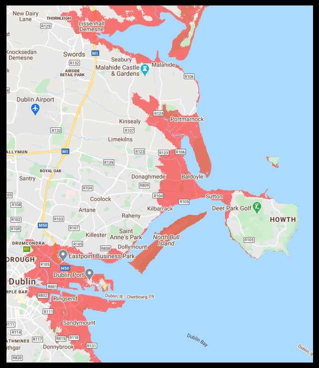
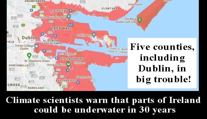
Climate scientists warn that parts of Ireland could be underwater in 30 years; five counties, including Dublin, in big trouble
Warning that climate change driven by human activity may endanger Ireland in the future. Climate scientists warn that parts of Ireland could be underwater in 30 years if drastic measures are not taken to prevent further climate change.
A roadmap indicates that heat waves will increase in Ireland and have a very detrimental effect. Heatwaves are becoming more severe in Ireland as a result of human activity that defies nature. According to the climate change map, parts of Ireland will be underwater by 2050, and five counties are in serious trouble if climate change continues to be severe.
If global warming reaches two degrees…
The findings are based on a predicted two-degree increase in global temperatures. Climate scientists expect this to happen in the next three decades.
Climate Central, a non-profit organisation based in the US that publishes climate news, revealed these shocking results based on estimates from peer-reviewed journals.
Climate change is already having an impact on the planet. Landslides, wildfires and floods are part of it.
Troubled counties and coastal areas
Homes in Dublin, Clare, Louth, Limerick and Galway are likely to be worst affected by climate change. Dublin will be the most affected of these counties in terms of the number of locations likely to be affected by high coastal water levels.
In Leinster, areas such as Dundalk, Haggardstown, Carlingford, Annagassan, Baltray, Bettystown and Laytown are at high risk. The map indicates that in 30 years, these areas may be at least partially below the annual flood level. There is a high risk of flooding in these areas due to various reasons.
Dublin coasts such as Portmarnock, Donabate, Swords, Howth and Malahide are also at risk. The map indicates that Bull Island, which already has a delicate ecosystem, is also at risk of flooding.
The capital’s Dublin 2 and Dublin 4 areas, as well as Ballsbridge, Sandymount, and Grand Canal Dock, are prone to flooding. Coastal areas such as Booterstown in south Dublin are also at risk.
In Munster, areas in and around the River Maigue in Limerick, including Adare, Clarina, and Creggaun, as well as areas around the River Shannon, are at risk of flooding in the next 10 years. Similarly, areas of Kerry including Listowel and Meevoo, are also at risk. Cork City will also be in crisis.

Rising sea level
Climate change is causing sea level rise. This happens for two reasons. The first is that rising sea temperatures are forcing glaciers and ice sheets to melt, adding more water to the ocean. Another reason is that global warming caused by climate change raises water temperatures, causing the water to expand and sea levels to rise.
As sea levels rise, parts of Ireland that are now on land may soon face severe floods as the coastline encroaches inward. The road map shows that even some urban areas will be below sea level by 2050.
This is just a screening tool
Climate Central warns that the map only provides estimations and should only be used as a screening tool. The map does not account for future storm frequency or intensity, erosion, inland floods, or how rainfall and rivers may contribute to sea level rise. The estimates also exclude sea protection measures like seawalls and levees. So some areas are less at risk than the map suggests.
Every disaster is a warning sign
Scientific analysis finds that the record high temperatures in 2019 in the UK and Europe and the devastating heatwaves that hit Canada and the US in recent weeks are the result of further intensification of global warming.
Scientists say that if there are no immediate global measures to reduce greenhouse gas emissions, it could become even more dangerous to the world. It says the earth has already warmed by about 1.2 degrees Celsius since pre-industrial times.
Kindly click the link below to join WhatsApp group chat to get important news and breaking news from Irish Samachar


Comments are closed.